About 20 miles outside of St. George, as we climbed an incline, we saw Noah’s Ark Rock Formation.

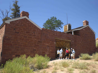
On our way to the Grand Canyon, North Rim, we stopped at Pipe Spring. Anson and Emmeline Winsor ran Pipe Spring for the first six years (it was established in 1870) and they called it Windsor Castle. This ranch was part of Brigham Young’s vision for the growing Mormon population. Mormons often tithed to the church in the form of cattle and the growing tithing herds needed more space. He also needed a source of beef and dairy products to feed hundreds of laborers working on the Mormon temple and other public projects in St. George. Pipe Springs was the perfect place because of the presence of water.

In 1879 the ranch was running more than 2,200 head of cattle. Even before the fort was completed, a relay station for the Deseret Telegraph system was installed, connecting this remote outpost on the Arizona Strip to other Mormon settlements and Salt Lake City, Utah. In the 1880s and 1890s the remote fort became a refuge for wives hiding from federal marshals enforcing anti-polygamy laws, which was an early Mormon doctrine. (we saw the homes of current polygamists as we drove through Colorado City). From 1881 to 1923 Mormon couples from Arizona stopped at Pipe Spring on their way to be married in the St. George Temple, which is why the road running by the fort was called the Honeymoon Trail. Faced with the confiscation of church property and the declining range, the Mormon Church sold Pipe Spring ranch in 1895.
We ended our day with a munchies party, hot dog & baked bean dinner and smores to top it off. Nothing like cooking over an open pit fire.
Day 6 – Grand Canyon, North Rim was a ride share day. It was much easier for everyone to go on their own so that they could spend as much time as they wanted in the different areas. It was great to find someone from our group at all of the different overlooks.

We could hardly contain ourselves from jumping out of the car to take pictures as we drove up the road to the lodge. We wanted to visit the lodge first (rub the donkey’s nose for good luck)

and then stop for pictures on the way back. The view was spectacular. The Grand Canyon is a must see because you just can’t imagine the true beauty, and to think the little ole Colorado River carved the Grand Canyon and the Kaibab Plateau.….
We started out at the Transept Trail

We started out at the Transept Trail


and the Bright Angel Trail. Looking across the canyon, you can see evidence of a fracture in the earth, the Bright Angel Fault. Bright Angel Canyon traces the route of the Right Angel Fault. 


Faults are fractures in the earth’s crust along which movement occurs. On the opposite cliff, an offset in the rock layers (light colored Coconino Sandstone) demonstrates the shift. The layers on the right of the fault rise about 150 feet higher than on the left. Bright Angel Fault is still active, producing small earthquakes which visitors sometimes feel.
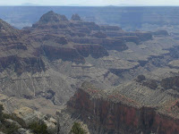
This is a photo looking down into the canyon.
This is a photo looking down into the canyon.

Major John Wesley Powell stated in 1869 that the Colorado River was “too thick to drink and too thin to plow.” Hmmmmm I believe I heard that while on the Lewis and Clark trip, but they said that about the Missouri River. I’ll have to look that up to find if our guide told us wrong about the Missouri River, or if Major Powell said that about several rivers. There are a few different theories on who the Colorado River cut through the Kaibab Plateau. Maybe they’ll figure it out in our lifetime—something to look forward to.
Next onto Cape Royal
And Angel’s Window (my favorite) which is the most dramatic view of the Colorado River. During the uplift of the Kaibab Plateau, stress and strain caused the rock to fracture forming vertical joints that intersect horizontal bedding planes. Weathering along these planes and joints has eroded a hole in the Kaibab limestone and enlarged it to form a window.

The top of the opposite side of the rim is the Desert View, which is about 8.5 miles away.
The top of the cliff to the left of the photo is Vishnu Temple, which is 2 miles away.

The Walhalla Plateau was the home to Anasiazi Indians 900 years ago. They are believed t be the ancestors of the Hopi Indians who live east of the Grand Canyon. During the winter months, they would be forced to live down in the canyon, while the summer months some of the people lived at the rim, an arduous 2 day walk. Archeologists have identified more than 300 prehistoric sites on this plateau, most of them close to the rim. The largest site contained a complex with 25 rooms. About 1150 A.D. these people left the Canyon, possibly because of a decline in rainfall.

Our last overlook stop was Roosevelt Point. On the far side of the Canyon most of the land is Navajo Indian Reservation. Beyond that on the distance horizon, lies the Painted Desert and the Hopi Indian Reservation. 


While at one of the overlooks, we saw a sign that said the rim is a favorite striking point for lightening, so if you have a lot of static electricity in your body, you might want to take cover during a storm!


