On the way to Bryce, we drove through Red Rock.


Bryce Canyon was my favorite when we vacationed with our son, Robby in 2001. I think because of the rich colors and the odd shaped “hoodoos,” a natural column of rock.
The rock progresses from “fins” to developing “windows” that later collapse to form hoodoos., In ancient times, they thought that men turned to stone and had powers. It was fun to see the different shapes of hoodoos as we traveled through the park. We found Queen Elizabeth,

chicken,

lion and Trojan horse,

King Tutt

Bill discovered ET on our hike 
Approximately 200 million years ago, the earth’s crust was crinkling throughout Nevada and into southern Canada. A strong, dense Pacific seafloor had smashed into North America’s weaker continental crust. Over 120 million years, compressional forces bent, folded, broke, and heaved our crust into the sky, giving birth to the Sevier Mountains. Rain and snow became geologic jackhammers, splitting mountains apart.
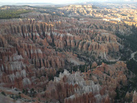
Just before dinosaurs went extinct (65 million years ago), the oceanic plate pushed up our continental crust uplifting land, forming the Rocky Mountains and warping Utah and Arizona. The rivers wore down the Sevier Mountains reaching the basin between the Sevier and Rockies, depositing layers of muds and silts., Lakes and ponds formed, but with no rivers flowing out of the basin, the sediment was trapped. Between 55-30 million years ago this mammouthb mud puddle, known as the Claron Basin, continued to fill with sediments rich in calcium carbonate – dissolved limestone (pink and white). Over time, these beds of sediment were compressed into rock and uplifted from 3,000 ft. to 9,000 feet in elevation 15 million years ago, forming the Colorado Plateau. About 8 million years ago, the Bryce Canyon area broke off this uplift as the Paunsaugunt Plateau and has been sinking ever since into the Great Basin. The freezing and thawing of water does most of the sculpting at Bryce Canyon, as opposed to a flowing river. In the photo below, the land as far as you can see use to be at the same level we were standing taking the picture. It is now 1,000 feet higher.

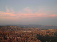
We went on an evening ranger walk on the rim of the canyon and learned that the canyon erodes between 1-4 feet per 100 years. They estimate that in 6 million years, Bryce Canyon will not exist. (he’ll be retired by then) Notice the difference in color as the sun went down. 


We took a 4 hour bus tour through the Canyon overlooks and had a wonderful bus driver/guide.
Of course everyone took a whiff. At the Agua Canyon Overlook, we were greeted by Vinny and Minnie Moocher who posed for pictures.

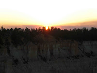
That evening, we took a group to see the sun set at Bryce Overlook. It is amazing how the rock formation colors become more enriched. I did not believe it could get more beautiful than when the sun is highlighting the canyon, but it does. 


On our free day, Marcia, Bill and I took a hike through the canyon, starting at Sunset Point and ending at Sunrise Point (yes we went backwards because it was easier to descent the steepest part of the hike. It was so beautiful that you can’t even imagine how different it looks from the bottom of the canyon as opposed to the rim. Around each turn everything looked different. It took us twice as long to do the hike because we had to keep stopping to take pictures and to just enjoy the scenery.
Can you believe we found these trees in the middle of the rock!

We found quite a few arches that we could walk through and as we hiked, we found stones marking paths, like the indians used to do. 


This was the horse path!!!!!!

Done at last!!!!!

We finished our day with a dinner buffet at the Ruby Inn Lodge – dejavue – it was the same place Bill, Robby, and I stayed when we visited in 2001!


No comments:
Post a Comment